The relevant media releases about the land additions to the Conservation Park:
Department for Environment and Water – More recreational…
I’ve reproduced the media release from the Premier’s office below:

The relevant media releases about the land additions to the Conservation Park:
Department for Environment and Water – More recreational…
I’ve reproduced the media release from the Premier’s office below:
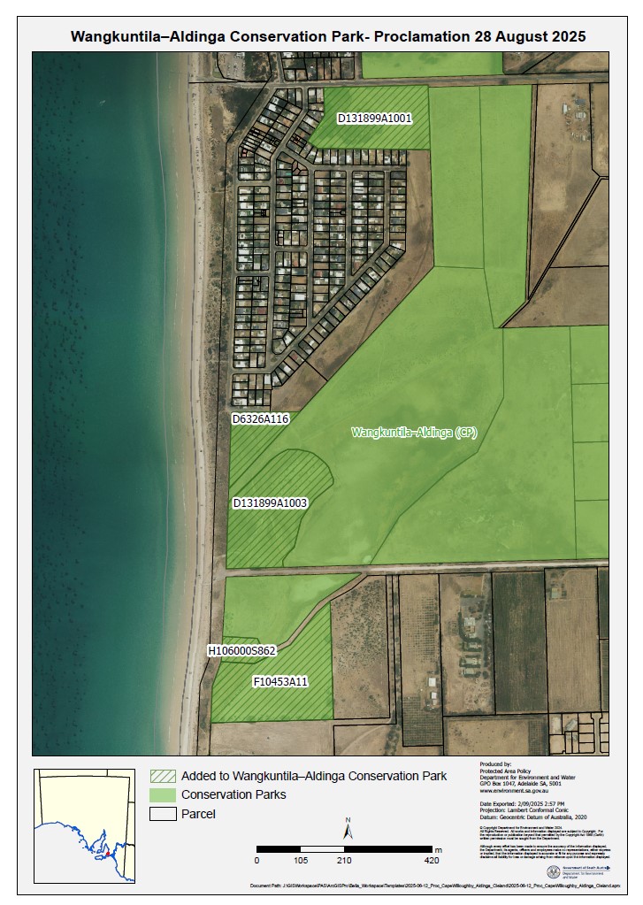
Exciting to see most of the remaining land parcels finally being added into the Aldinga Conservation Park. The Park also has a new name – Wangkuntila–Aldinga Conservation Park. The parcels adjacent to the Silver Sands housing area have stormwater complications – it remains to be seen whether these will be resolved and these parcels also added.
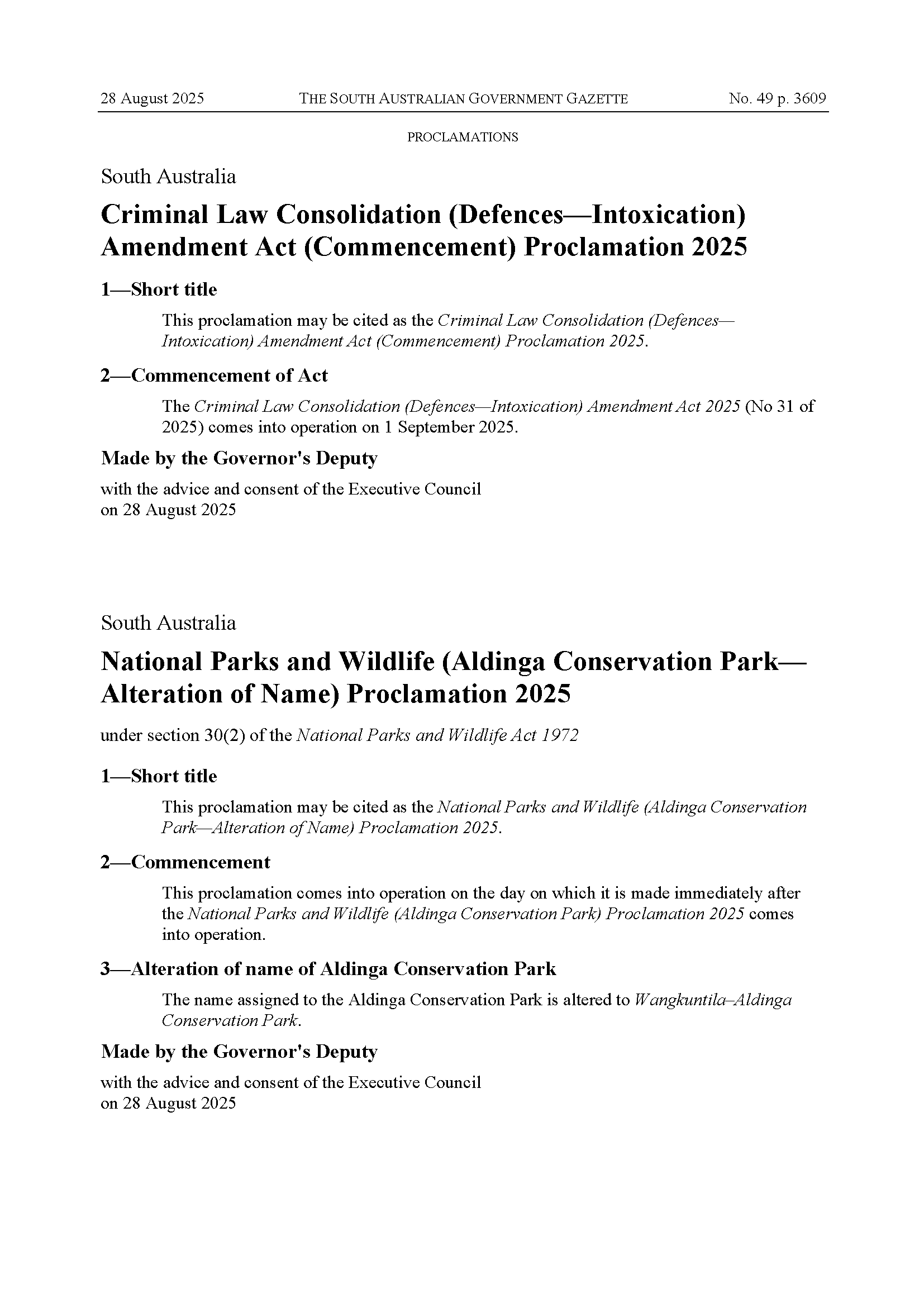
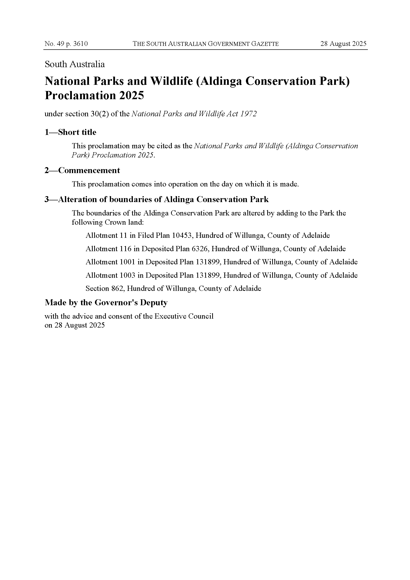
Gazette proclamations below (ignore the Criminal Law proclamation), as well as the updated park map (hatched areas are the new additions – the Blue Lagoon site is in the northwest):
Sourced from: https://www.mediastatements.wa.gov.au/Pages/McGowan/2022/11/Community-invited-to-comment-on-sandalwood-management.aspx
Western Australians can now have their say on the conservation and use of sandalwood over the next five years.
The draft Sandalwood Biodiversity Management Programme aims to stabilise wild sandalwood and outlines how it can be sustained into the future.
Sandalwood (Santalum spicatum) is a slow-growing tree found across 146 million hectares of the Wheatbelt, Goldfields, Murchison, Gascoyne and southern Pilbara. Extensive agricultural clearing has seen wild sandalwood dwindle over the past 200 years, particularly in the Wheatbelt. It’s also been impacted by illegal harvesting, pests, grazing and bushfires.
The draft programme prepared by the Department of Biodiversity, Conservation and Attractions sets out how wild sandalwood will be conserved, protected and managed, consistent with the requirements of the Biodiversity Conservation Act 2016. It will not apply to plantation sandalwood.
The public comment period is open until 9 December. To have your say, visit http://www.dbca.wa.gov.au/sandalwood
Comments attributed to Environment Minister Reece Whitby:
“Sandalwood is a unique resource and we’re committed to protecting and sustaining this remarkable species for generations to come.
“This will apply to the management of wild sandalwood on both Crown and private land, but won’t apply to plantation sandalwood.
“Having your say will help us understand any industry or community concerns to help shape the management of this important native species.”
Good Evening Michael,
Apologies for the length of time it’s taken to get back to you.
Since we last exchanged emails on this topic we have discovered there is a bit more to this issue than we originally thought. We’ve engaged with the DEW Parks Marketing team to get a better understanding of the information that the department already provides to Google – this has helped to define the scope of what we need to consider. Here is a summary of what we have uncovered.
Information Discovery
o park name
o park address
o contact phone number
o opening times
o web link to DEW Parks web site – eg Belair National… – National Parks and Wildlife Service South Australia
o an (XY) map coordinate to define the centroid for the park – for Google functions like display, zoom and obtaining directions
Considerations
o For example, the use of park type abbreviations in the park name in our mapping layer is likely to be different to that required for public use, as currently delivered through the Business Profile account – some reformatting of park information will be required
Related Issue
Next Steps
We’re currently looking to arrange a conversation with a Google contact so that we can discuss these issues and hopefully identify options for providing the required information (for both Parks Business and Mapping) in a coordinated approach – ideally without the need for overlapping accounts.
Thanks for your patience whilst we work through these issues.
Kind Regards, Online Mapping Support
DEW Online Mapping
Department for Environment and Water
GPO Box 1047, Adelaide, SA 5001
environment.sa.gov.au
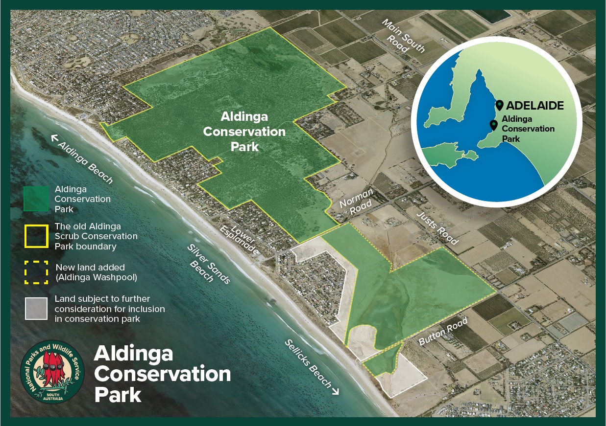
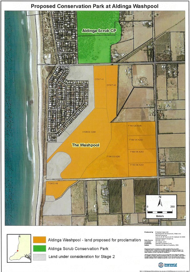
SA Government media release: https://www.premier.sa.gov.au/news/media-releases/news/aldinga-washpool-officially-saved-for-future-generations
Reproduced below:
The Aldinga Washpool, one of Adelaide’s last remaining coastal freshwater and estuarine lagoon systems, has now been combined with the adjacent Aldinga Scrub Conservation Park to create the state’s newest conservation park.
Premier Steven Marshall said the proclamation was a significant milestone for the local community and supporters.
“By combining the Aldinga Washpool land with the nearby Aldinga Scrub Conservation Park it’s created a fantastic new ecological and cultural haven just south of Adelaide,” Premier Marshall said.
“This adds to my government’s commitment to protect our state’s natural environment by doubling the area covered by national parks, investing record levels of funding to improve conservation, increase visitor numbers and boost our regional economies.
“Importantly the Aldinga Washpool site is of considerable spiritual and cultural significance to the Kaurna people who today maintain their connection with Country.”
Minister for Environment and Water David Speirs said the local community had long advocated for better protection of the site.
“In 2018, an Aldinga Washpool Working Group was established, and we have been working closely with this group to ensure the land’s environmental and cultural values are protected and restored,” Minister Speirs said.
“For years the future of the Aldinga Washpool was under threat so it’s incredibly pleasing for the local community to be able to see this important site saved for future generations.
“This further adds to our record expansion of area protected in South Australia, which has seen us increase the number of national parks across the state from 21 to 29 and double the area protected from approximately 3.90 million hectares to just over 7.9 million hectares.
“This record expansion is backed up by the biggest ever government investment in parks to boost conservation as well as improve our standing as a world-class eco-tourism destination
“Adelaide has been recognised as the third most liveable city in the world and it was recently named as the second-ever National Park City and our record expansion of parks and green space will only enhance this reputation.”
The Aldinga Washpool includes valuable habitat for at least 79 native species, including three bird species of national conservation significance. It is also home to swamp plants of conservation significance including threatened coastal saltmarsh.
Prior to European settlement, the Aldinga Washpool was an important place for curing and drying possum skins by the Kaurna people. It is also a significant site as part of the Tjilbruke Dreaming Trail and contains registered sites under the Aboriginal Heritage Act 1988 (SA).
The land being added to the state reserves system in this proclamation includes a combination of land previously transferred from SA Water, the Coast Protection Board and the City of Onkaparinga.
The Department for Environment and Water, SA Water, Green Adelaide, City of Onkaparinga and other working group members have been working on flood mitigation, stormwater management, weed control, revegetation plans, water quality and protection of Aboriginal cultural heritage.
The proclamation of the Aldinga Conservation Park adds to the eight national parks created since 2018 including Glenthorne National Park, Hindmarsh Valley National Park, Munga-Thirri–Simpson Desert National Park, Nilpena Ediacara National Park, Wapma Thura – Southern Flinders Ranges National Park, Lake Frome National Park, Cleland National Park and Deep Creek National Park.
New map from the National Parks and Wildlife Service SA (also at: https://www.parks.sa.gov.au/park-management/aldinga-conservation-park)
Michael Cornish
to: [email protected]
date: 22 Nov 2021
subject: Recommendation that Sandalwood be added to the priority flora list
Dear WA TSSC,
Just in case the process has not been initiated, may I please recommend that Sandalwood be added to the priority flora list?
The basis for this recommendation comes from the attached correspondence between myself and the Chair of the WA TSSC.
Kind regards,
-Michael Cornish
As per correspondence viewed, dated 15 November 2021:
The same letter was also sent to the Shadow Minister for the Environment and Water, the Hon Susan Close MP.
The Hon David Speirs MP
Minister for Environment and Water
GPO BOX 1047
ADELAIDE SA 5001
Dear Minister,
Re: State election commitments on Air Quality Monitoring
I write to you as a former Senior Policy Adviser to the Federal Member for Mayo, Rebekha Sharkie MP, with a keen interest in the environment and public health.
I note that there are currently no Air Quality Monitoring[1] sites in the Adelaide metropolitan area north or north-east of the Air Quality Monitoring site at Northfield, leaving large communities in the northern and north-eastern suburbs – including the marginal electorates of Wright and King, and to a lesser extent, Newland – without access to air quality data. Based on 2016 Census data, this area accounts for at approximately 348,000 people[2], which is over 26% of the 2016 population of metropolitan Adelaide[3]. Unfortunately, climate change is set to increase the prevalence and impact of bushfires and smoke, leading to an increase in community air quality concerns.
Air quality data is particularly valuable to vulnerable groups, such as the young, the elderly, and people with respiratory problems who can face life-threatening consequences from poor quality air. For example, an estimated 11% of the population have asthma[4], meaning there are an estimated more than 38,000 asthmatics within the north/north-eastern metropolitan Adelaide area, let alone other vulnerable groups.
Will your party commit to establishing an Air Quality Monitoring site in an appropriate location in the northern/north-eastern suburbs of Adelaide?
Further, will your party commit to this site measuring NO2, PM10 (1 hour), PM10 (24 hours), and O3 (1 hour) and O3 (4 hours), noting that this would simply mirror the monitoring undertaken at the southernmost metropolitan Adelaide monitoring site at Christies Beach?
Yours sincerely,
Michael Cornish
12 / 11 / 2021
[1] See: https://www.epa.sa.gov.au/environmental_info/air_quality/new-air-quality-monitoring
[2] 137,979 people in the City of Salisbury; 23,034 in the Town of Gawler; 97,734 in City of Tea Tree Gully; 89,372 in the City of Playford; see: https://www.abs.gov.au/websitedbs/D3310114.nsf/Home/2016%20QuickStats
[3] 1,295,714 people as of the 2016 Census in the Greater Adelaide, Greater Capital City Statistical Area; see: https://quickstats.censusdata.abs.gov.au/census_services/getproduct/census/2016/quickstat/4GADE?opendocument
[4] As per: https://www.aihw.gov.au/reports/chronic-respiratory-conditions/asthma/contents/asthma