SA Government media release: https://www.premier.sa.gov.au/news/media-releases/news/aldinga-washpool-officially-saved-for-future-generations
Reproduced below:
The Aldinga Washpool, one of Adelaide’s last remaining coastal freshwater and estuarine lagoon systems, has now been combined with the adjacent Aldinga Scrub Conservation Park to create the state’s newest conservation park.
Premier Steven Marshall said the proclamation was a significant milestone for the local community and supporters.
“By combining the Aldinga Washpool land with the nearby Aldinga Scrub Conservation Park it’s created a fantastic new ecological and cultural haven just south of Adelaide,” Premier Marshall said.
“This adds to my government’s commitment to protect our state’s natural environment by doubling the area covered by national parks, investing record levels of funding to improve conservation, increase visitor numbers and boost our regional economies.
“Importantly the Aldinga Washpool site is of considerable spiritual and cultural significance to the Kaurna people who today maintain their connection with Country.”
Minister for Environment and Water David Speirs said the local community had long advocated for better protection of the site.
“In 2018, an Aldinga Washpool Working Group was established, and we have been working closely with this group to ensure the land’s environmental and cultural values are protected and restored,” Minister Speirs said.
“For years the future of the Aldinga Washpool was under threat so it’s incredibly pleasing for the local community to be able to see this important site saved for future generations.
“This further adds to our record expansion of area protected in South Australia, which has seen us increase the number of national parks across the state from 21 to 29 and double the area protected from approximately 3.90 million hectares to just over 7.9 million hectares.
“This record expansion is backed up by the biggest ever government investment in parks to boost conservation as well as improve our standing as a world-class eco-tourism destination
“Adelaide has been recognised as the third most liveable city in the world and it was recently named as the second-ever National Park City and our record expansion of parks and green space will only enhance this reputation.”
The Aldinga Washpool includes valuable habitat for at least 79 native species, including three bird species of national conservation significance. It is also home to swamp plants of conservation significance including threatened coastal saltmarsh.
Prior to European settlement, the Aldinga Washpool was an important place for curing and drying possum skins by the Kaurna people. It is also a significant site as part of the Tjilbruke Dreaming Trail and contains registered sites under the Aboriginal Heritage Act 1988 (SA).
The land being added to the state reserves system in this proclamation includes a combination of land previously transferred from SA Water, the Coast Protection Board and the City of Onkaparinga.
The Department for Environment and Water, SA Water, Green Adelaide, City of Onkaparinga and other working group members have been working on flood mitigation, stormwater management, weed control, revegetation plans, water quality and protection of Aboriginal cultural heritage.
The proclamation of the Aldinga Conservation Park adds to the eight national parks created since 2018 including Glenthorne National Park, Hindmarsh Valley National Park, Munga-Thirri–Simpson Desert National Park, Nilpena Ediacara National Park, Wapma Thura – Southern Flinders Ranges National Park, Lake Frome National Park, Cleland National Park and Deep Creek National Park.
New map from the National Parks and Wildlife Service SA (also at: https://www.parks.sa.gov.au/park-management/aldinga-conservation-park)
As per correspondence viewed, dated 15 November 2021:
24 August 2021
Good Afternoon Michael,
Thanks for your query to NatureMaps Support and our apologies for the length of time it has taken to get back to you.
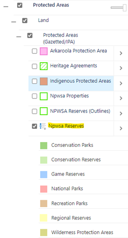
In case you weren’t aware, the Department for Environment and Water makes some of its key spatial data layers openly accessible through the Data SA web site – Data.SA. You can find a version of the NPWSA Reserves layer (ie South Australian reserves dedicated under the National Parks and Wildlife Act, Wilderness Protection Act and reserves for conservation purposes under the Crown Land Management Act) in the following location – Conservation Reserve Boundaries – Dataset – data.sa.gov.au. This version of the data is equivalent to the NPWSA Reserves layer in NatureMaps – see screenshot below
The procedure for supplying data to Google has changed over the years. Previously, Google acquired a series of Australia-wide foundation data sets (including parks and reserves) from a National mapping distributor. These National mapping data sets were updated on a regular basis from authoritative data supplied from State and Territory mapping agencies. Under this approach, there was a clear pathway to provide updated mapping data to national and broader mapping initiatives.
Google has since stopped acquiring Australia-wide data from this National mapping distributor and now seems to favour a different approach for updating data.
Looking at information online, Google now promotes a Google Maps Content Providers program – Google Maps Content Partners – Content Providers – Google Maps. Map Content Partners can provide their own data to improve information displayed on Google Maps – it looks like Parks and Protected Areas are part of the data that Google will accept.
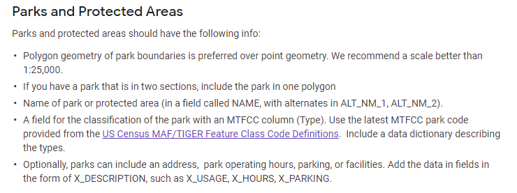
In order to submit mapping data under this partner program, Google has published some guidelines defining the required format and structure of the mapping data to be provided – Geo Data Upload Content Requirements – Map Content Partners Help (google.com). For mapping data representing Parks and Protected Areas, partner data will need to adhere to the following guidelines.
Based on these guidelines, the South Australian NPWSA Reserves layer displayed in NatureMaps will require some “translation” to a data structure that will comply with the Google mapping requirements. For this reason, it is probably best that this work is done by the department so that consistent routines can be established as part of a regular supply mechanism for Google mapping purposes.
We’ll coordinate with the department’s Parks and Communications teams to determine a way forward.
Thanks again for your interest. Please let us know if you have any further questions.
Regards, NatureMaps Support
DEW Online Mapping
Science and Information Branch | Strategy Science and Corporate Services Division
Department for Environment and Water
81 – 95 Waymouth Street Adelaide, SA 5000
GPO Box 1047, Adelaide, SA 5001
environment.sa.gov.au
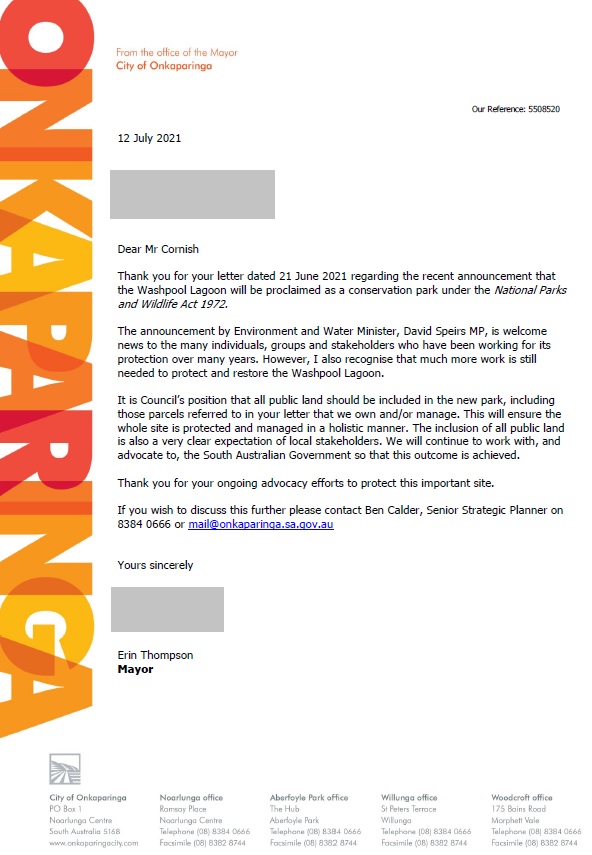
Also confirmed through phone call on 12 July 2021 that the current City of Onkaparinga Council position on the Washpool is contained as a motion within the 4 May 2021 minutes of their Strategic Directions Committee, namely, acceptance of the Item 7.4 Washpool Lagoon – Council’s Role report.
NatureMaps Support
Enviro Data SA
SA Department for Environment and Water
e: [email protected]
Dear NatureMaps Support,
Re: GIS data for Nature Parks and Wildlife SA (NPWSA) Reserves outlines
Thank you in advance for your time and consideration of my correspondence and for maintaining the NatureMaps application and website.
I am writing in my personal capacity with a keen interest in environmental conservation and in public accessibility to – and enjoyment of – our natural environment.
Google Maps is widely used by South Australians and visitors to our state to navigate to sites of public interest, including NPWSA Reserves, especially National Parks, Conservation Parks, and Recreation Parks. Currently, Google Maps is missing the outlines of several significant South Australian NPWSA sites, including Para Wirra Conservation Park, Anstey Hill Recreation Park, Cobbler Creek Recreation Park, Glenthorne National Park, and Sturt Gorge Recreation Park, to name but a few. I note that mapping of the NPWSA Reserves (outlines) data layer is available via the NatureMaps application.
For example, since providing GIS coordinates for Lawari CP to Google Maps a few years ago, there have been 50,000 public views of the photos assigned in Google Maps to the Park. Hopefully this demonstrates the public value, and especially tourism value, in having NPWSA sites properly shown on public mapping applications.
May I kindly request, can Enviro Data SA provide me with the GIS data – or instructions on how to access that data – for the NPWSA Reserves (outlines), noting my intention to provide this data to Google Maps?
If not, would Enviro Data SA be willing to provide the data directly to Google Maps?
Would it be possible to set up a process by which the data could regularly be made available (for example, annually) to publicly accessible mapping providers such as Google Maps?
Thank you again for your time and consideration of my correspondence.
Yours sincerely,
Michael Cornish
4 / 7 / 2021
Mayor Erin Thompson
City of Onkaparinga
PO Box 1
Noarlunga Centre SA 5168
Dear Mayor Thompson,
Re: City of Onkaparinga, Aldinga Washpool, and the new Conservation Park
I hope this correspondence finds you well; you would remember me from my time as former Senior Policy Adviser to Ms Rebekha Sharkie MP. Thank you for your own ongoing efforts and support for permanent conservation of the Aldinga Washpool site.
I am writing to you in my personal capacity and out of a keen interest in environmental conservation. The permanent conservation of Aldinga Washpool was an issue I worked upon during my employment with Ms Sharkie, and since then I have been providing advice to the local Washpool Coalition and undertaking my own advocacy on the issue with the State Government.
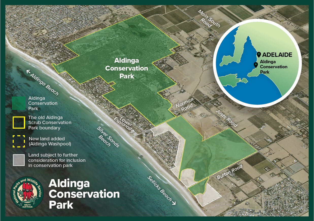
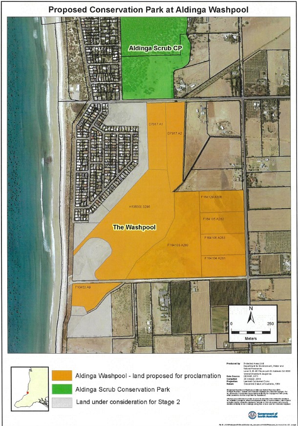
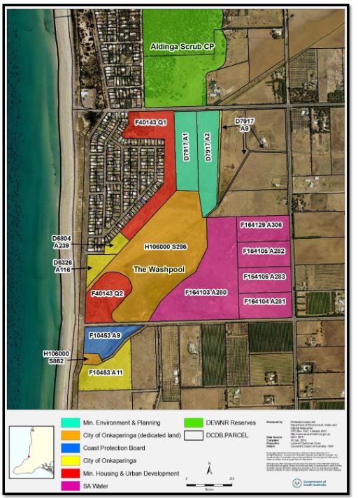
I too am concerned that there are land parcels at the Aldinga Washpool site that have yet to be confirmed will be a part of the eventual conservation park (as shown in the map at: https://www.parks.sa.gov.au/park-management/aldinga-washpool). These include land parcels which I understand are directly owned by the City of Onkaparinga, or is Crown land under their care, namely:
May I kindly request an update on whether these parcels are still under Council ownership (and/or care), and whether there is active consideration for their addition to the new Conservation Park?
If so, what is the likely process (such as a vote at Council) and timing for a decision to be made by the City of Onkaparinga?
Thank you again for your support on this issue and for your time and consideration.
Yours sincerely,
Michael Cornish
21 / 6 / 2021
Cc Mr Geoff Hayter, Chair, Washpool Coalition
[Map reproduced from: https://www.parks.sa.gov.au/park-management/aldinga-washpool]

[Map reproduced from page 8, Washpool Lagoon Vegetation Survey and Mapping 2016, available here: https://www.naturalresources.sa.gov.au/files/sharedassets/adelaide_and_mt_lofty_ranges/coast_and_marine/aldinga-washpool-lagoon-vegetation-survey-mapping-2016-rep.pdf]
[Reproduced from: https://www.premier.sa.gov.au/news/media-releases/news/aldinga-washpool-to-become-a-protected-area]
19/06/2021 | David Speirs MP
One of Adelaide’s last remaining coastal freshwater and estuarine lagoon systems will form part of a new conservation park at Aldinga with the Marshall Liberal Government stepping in to protect the area from potential housing development.
Aldinga Washpool, in Adelaide’s south is a well-known habitat for a wide range of native species, particularly birds and swamp plants of conservation significance, including a threatened coastal saltmarsh that’s nationally listed as a vulnerable threatened ecological community.
The Washpool is also of considerable spiritual and cultural significance to the Kaurna people and contains numerous archaeological sites and artefacts.
Minister for Environment and Water David Speirs said the Washpool land will be combined with the adjacent Aldinga Scrub Conservation Park to create one new conservation park.
“This is a significant moment for the local community who have been championing for the Aldinga Washpool to be protected for decades,” Minister Speirs said.
“The Marshall Liberal Government is committed to improving conservation and increasing the amount of open, green space available for people to explore and by combining the Aldinga Washpool land with the nearby Aldinga Scrub Conservation Park we will create a fantastic ecological and cultural haven just south of Adelaide.
“This follows the creation of Adelaide’s second metropolitan national park at Glenthorne and builds on our government’s record investment in open space and our historic push to increase the amount of space protected as national parks across the state.
“This is in stark contrast to the former Labor Government who ripped funding away from the environment and failed to rule out selling off these precious pieces of land to developers.
“In 2018, a Washpool Working Group was established, and we have been working closely with this group to ensure the land’s cultural and environmental values be protected and restored.
“The Department for Environment and Water, SA Water, Green Adelaide, City of Onkaparinga and other members of the working group have been working on flood mitigation, stormwater management, weed control, revegetation plans, water quality and protection of Aboriginal cultural heritage.”
“We will now work with the local community about the future management, and a planning process will commence next year to consolidate hydrological, ecological, and cultural work done so far.”
Recognising its cultural and environmental significance, and that it’s now surplus to SA Water operational requirements, the entirety of the Aldinga Washpool land has been transferred, encompassing five allotments totalling 31.64 hectares. There is also a mix of State Government tenures in the process of being transferred.
When complete, the total area of land added to park will be about 74 hectares.