Tag Archives: Park

Update 1: GIS data for SA nature park outlines

Good Evening Michael,

Apologies for the length of time it’s taken to get back to you.

Since we last exchanged emails on this topic we have discovered there is a bit more to this issue than we originally thought.  We’ve engaged with the DEW Parks Marketing team to get a better understanding of the information that the department already provides to Google – this has helped to define the scope of what we need to consider.  Here is a summary of what we have uncovered.

Information Discovery

  • The department is already providing information to Google for high visitation parks through a Google Business Profile account.
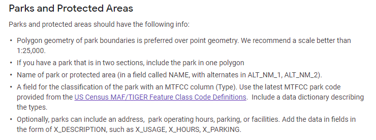
  • The information provided includes:

o   park name

o   park address

o   contact phone number

o   opening times

o   web link to DEW Parks web site – eg Belair National… – National Parks and Wildlife Service South Australia

o   an (XY) map coordinate to define the centroid for the park – for Google functions like display, zoom and obtaining directions

  • This is an example of the information for Belair National Park –  Belair National park – Google Search
  • An additional Google Map Content Partner account would be required to upload mapping data representing park boundaries to Google for inclusion on Google map products

Considerations

  • The Google Business Profile and Map Content Partner accounts are not the same – we are not able to use the existing departmental Business Profile account to upload mapping data.
  • There is an overlap in the park information that can be provided to Google by each account – this means there is a potential to provide conflicting information for a park, unless there is careful curation of park information content.

o   For example, the use of park type abbreviations in the park name in our mapping layer is likely to be different to that required for public use, as currently delivered through the Business Profile account – some reformatting of park information will be required

  • As mentioned in our previous email, Google has published some guidelines defining the required format and structure of mapping data to be provided by a Map Content Partner account – Geo Data Upload Content Requirements – Map Content Partners Help (google.com).  For mapping data representing Parks and Protected Areas, our park mapping data will need to be translated to meet the guidelines below.  This will require an automated (scripted) translation process if were are to provide parks mapping data to Google on a regular basis.


Related Issue

  • We’ve also been informed of a related issue – there is a need to provide map coordinates to identify the main entrance / public access points for a park.  This is to help provide more accurate directions in Google maps.
  • At the moment the directions function in Google does not always guide visitors to the most logical access point for a park – see example below


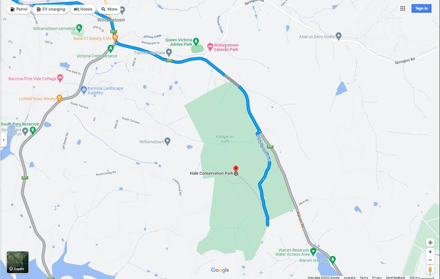
  • In some cases this will require verification with regional parks staff to ensure we are providing up-to-date access information.

Next Steps

We’re currently looking to arrange a conversation with a Google contact so that we can discuss these issues and hopefully identify options for providing the required information (for both Parks Business and Mapping) in a coordinated approach – ideally without the need for overlapping accounts.

Thanks for your patience whilst we work through these issues.

Kind Regards,  Online Mapping Support

DEW Online Mapping

Department for Environment and Water

GPO Box 1047, Adelaide, SA 5001
environment.sa.gov.au

Update 8: Aldinga Washpool

SA Government media release: https://www.premier.sa.gov.au/news/media-releases/news/aldinga-washpool-officially-saved-for-future-generations

Reproduced below:


21/01/2022 | Steven Marshall MP | David Speirs MP
A new 340-hectare park in Adelaide’s south is set to become a coastal environmental, recreational and cultural haven for generations to come, with the official proclamation of the Aldinga Conservation Park.

The Aldinga Washpool, one of Adelaide’s last remaining coastal freshwater and estuarine lagoon systems, has now been combined with the adjacent Aldinga Scrub Conservation Park to create the state’s newest conservation park.

Premier Steven Marshall said the proclamation was a significant milestone for the local community and supporters.

“By combining the Aldinga Washpool land with the nearby Aldinga Scrub Conservation Park it’s created a fantastic new ecological and cultural haven just south of Adelaide,” Premier Marshall said.

“This adds to my government’s commitment to protect our state’s natural environment by doubling the area covered by national parks, investing record levels of funding to improve conservation, increase visitor numbers and boost our regional economies.

“Importantly the Aldinga Washpool site is of considerable spiritual and cultural significance to the Kaurna people who today maintain their connection with Country.”

Minister for Environment and Water David Speirs said the local community had long advocated for better protection of the site.

“In 2018, an Aldinga Washpool Working Group was established, and we have been working closely with this group to ensure the land’s environmental and cultural values are protected and restored,” Minister Speirs said.

“For years the future of the Aldinga Washpool was under threat so it’s incredibly pleasing for the local community to be able to see this important site saved for future generations.

“This further adds to our record expansion of area protected in South Australia, which has seen us increase the number of national parks across the state from 21 to 29 and double the area protected from approximately 3.90 million hectares to just over 7.9 million hectares.

“This record expansion is backed up by the biggest ever government investment in parks to boost conservation as well as improve our standing as a world-class eco-tourism destination

“Adelaide has been recognised as the third most liveable city in the world and it was recently named as the second-ever National Park City and our record expansion of parks and green space will only enhance this reputation.”

The Aldinga Washpool includes valuable habitat for at least 79 native species, including three bird species of national conservation significance. It is also home to swamp plants of conservation significance including threatened coastal saltmarsh.

Prior to European settlement, the Aldinga Washpool was an important place for curing and drying possum skins by the Kaurna people. It is also a significant site as part of the Tjilbruke Dreaming Trail and contains registered sites under the Aboriginal Heritage Act 1988 (SA).

The land being added to the state reserves system in this proclamation includes a combination of land previously transferred from SA Water, the Coast Protection Board and the City of Onkaparinga.

The Department for Environment and Water, SA Water, Green Adelaide, City of Onkaparinga and other working group members have been working on flood mitigation, stormwater management, weed control, revegetation plans, water quality and protection of Aboriginal cultural heritage.

The proclamation of the Aldinga Conservation Park adds to the eight national parks created since 2018 including Glenthorne National Park, Hindmarsh Valley National Park, Munga-Thirri–Simpson Desert National Park, Nilpena Ediacara National Park, Wapma Thura – Southern Flinders Ranges National Park, Lake Frome National Park, Cleland National Park and Deep Creek National Park.


New map from the National Parks and Wildlife Service SA (also at: https://www.parks.sa.gov.au/park-management/aldinga-conservation-park)

Update 1: GIS data for SA nature park outlines

24 August 2021

Good Afternoon Michael,

Thanks for your query to NatureMaps Support and our apologies for the length of time it has taken to get back to you.

In case you weren’t aware, the Department for Environment and Water makes some of its key spatial data layers openly accessible through the Data SA web site – Data.SA.  You can find a version of the NPWSA Reserves layer (ie South Australian reserves dedicated under the National Parks and Wildlife Act, Wilderness Protection Act and reserves for conservation purposes under the Crown Land Management Act) in the following location – Conservation Reserve Boundaries – Dataset – data.sa.gov.au.  This version of the data is equivalent to the NPWSA Reserves layer in NatureMaps – see screenshot below


The procedure for supplying data to Google has changed over the years.  Previously, Google acquired a series of Australia-wide foundation data sets (including parks and reserves) from a National mapping distributor.  These National mapping data sets were updated on a regular basis from authoritative data supplied from State and Territory mapping agencies.  Under this approach, there was a clear pathway to provide updated mapping data to national and broader mapping initiatives.

Google has since stopped acquiring Australia-wide data from this National mapping distributor and now seems to favour a different approach for updating data.

Looking at information online, Google now promotes a Google Maps Content Providers program – Google Maps Content Partners – Content Providers – Google Maps.  Map Content Partners can provide their own data to improve information displayed on Google Maps – it looks like Parks and Protected Areas are part of the data that Google will accept.

In order to submit mapping data under this partner program, Google has published some guidelines defining the required format and structure of the mapping data to be provided – Geo Data Upload Content Requirements – Map Content Partners Help (google.com).  For mapping data representing Parks and Protected Areas, partner data will need to adhere to the following guidelines.

Based on these guidelines, the South Australian NPWSA Reserves layer displayed in NatureMaps will require some “translation” to a data structure that will comply with the Google mapping requirements.  For this reason, it is probably best that this work is done by the department so that consistent routines can be established as part of a regular supply mechanism for Google mapping purposes.

We’ll coordinate with the department’s Parks and Communications teams to determine a way forward.

Thanks again for your interest.  Please let us know if you have any further questions.

Regards, NatureMaps Support

DEW Online Mapping

Science and Information Branch | Strategy Science and Corporate Services Division
Department for Environment and Water
81 – 95 Waymouth Street Adelaide, SA 5000
GPO Box 1047, Adelaide, SA 5001
environment.sa.gov.au

GIS data for SA nature park outlines

NatureMaps Support
Enviro Data SA
SA Department for Environment and Water
e: [email protected]


Dear NatureMaps Support,

Re: GIS data for Nature Parks and Wildlife SA (NPWSA) Reserves outlines

Thank you in advance for your time and consideration of my correspondence and for maintaining the NatureMaps application and website.

I am writing in my personal capacity with a keen interest in environmental conservation and in public accessibility to – and enjoyment of – our natural environment.

Google Maps is widely used by South Australians and visitors to our state to navigate to sites of public interest, including NPWSA Reserves, especially National Parks, Conservation Parks, and Recreation Parks. Currently, Google Maps is missing the outlines of several significant South Australian NPWSA sites, including Para Wirra Conservation Park, Anstey Hill Recreation Park, Cobbler Creek Recreation Park, Glenthorne National Park, and Sturt Gorge Recreation Park, to name but a few. I note that mapping of the NPWSA Reserves (outlines) data layer is available via the NatureMaps application.

For example, since providing GIS coordinates for Lawari CP to Google Maps a few years ago, there have been 50,000 public views of the photos assigned in Google Maps to the Park. Hopefully this demonstrates the public value, and especially tourism value, in having NPWSA sites properly shown on public mapping applications.

May I kindly request, can Enviro Data SA provide me with the GIS data – or instructions on how to access that data – for the NPWSA Reserves (outlines), noting my intention to provide this data to Google Maps?

If not, would Enviro Data SA be willing to provide the data directly to Google Maps?

Would it be possible to set up a process by which the data could regularly be made available (for example, annually) to publicly accessible mapping providers such as Google Maps?

Thank you again for your time and consideration of my correspondence.

Yours sincerely,

Michael Cornish

4 / 7 / 2021

The former Le-Cornu site

Mr Peter Tsokas
Chief Executive Officer
City of Unley
PO Box 1
Unley SA 5061

Dear Mr Tsokas

RE: Council green space and former Le-Cornu site

I am a resident of Ashford with a young family adjacent to the border of the City of Unley.  With the sale of the former Le Cornu site on Anzac Highway to Kaufland having now fallen through, I write to advocate for the City of Unley to consider turning all or part of that block into a public park.

With increasing urban density in the inner ring of Adelaide – in short, more apartment and townhouse dwellers – outdoor public green spaces are becoming increasingly important. I note that the City of Unley has performed excellently in this regard – according to the 2020 Greener Spaces, Better Places report (‘Where will all the trees be?’) your council has had an impressive 3% increase in green cover from between 2016 to 2020.  Under your stewardship, hopefully the City of Unley is willing to continue this excellent trend!

Even a thin sliver of green space at the eastern end of the allotment that also provided north-south access between Leader Street and Maple Street (as currently there is none along the length of the block) would be welcome addition for local residents and workers, making the area more permeable for people on bicycles or on foot.

May I please inquire as to whether the City of Unley has considered purchasing any or all of the site as a public green space, ideally as a park?

In the absence of broader plans, would the City of Unley consider purchasing a small north-south corridor at the eastern end of the allotment to provide at least some green space, as well as access between Maple and Leader streets?

Thank you again for your time and consideration of my letter.

All the best,

Mr Michael Cornish

1 / 3 / 21

Cc Cr Emma Wright, Goodwood Ward
Cc Cr Nicole Sheehan, Goodwood Ward